


وصف لـ Anchor Alarm - SailGrib AA
Anchor Alarm by SailGrib, is a modern full featured anchor alarm app.
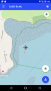
- Start the app before your anchor, the app will record and draw your track on a map.
- Leave your phone on the chart table.
- Moore without worrying about the application.
- Return to the application.On the track, locate the point corresponding to the boat's position at the time of anchoring. You should be able to detect it relatively easily on the map thanks to the reverse movement after anchoring.
- Center the map on the anchor point using the target sign in the middle of the screen.
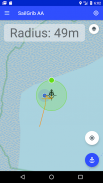
- Press the blue "Anchor" button to fix the anchor position.
- Adjust the radius of the wetting area by moving the green dot to the edge of the zone.
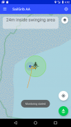
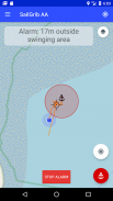
- Fix the wetting area by pressing the "Anchor" button again, it turns green. The alarm is activated.
NEW: Use your Navionics boating charts within the app!
With the Premium option:
- Define a hexagonal and editable wetting zone on the screen.
- Send a mail when an alarm is raised.
- View SailGrib WR maps.
- Import the GPX trace of SailGrib WR if you forgot to start the application before wetting.
The app runs in the background and uses the latest Android techniques to reduce power consumption while maximizing position accuracy.
Note that the accuracy of your position depends on your phone and your location. As of December 2017, we consider that most phones have an accuracy between 5 and 10 meters while at sea. New phones that use the Galileo constellation, have an accuracy
around 1 m. Starting in June 2018, some phones should have a sub-meter accuracy. Check our FAQs (https://www.sailgrib.com/sailgrib-aa-support/) to get a list of the best phones.
مرساة التنبيه من SailGrib ، هو التطبيق إنذار مرساة حديث كامل كامل.
- بدء التطبيق قبل مرساة الخاص بك ، فإن التطبيق تسجيل ورسم المسار الخاص بك على الخريطة.
- اترك هاتفك على طاولة الرسم البياني.
- مور دون القلق بشأن التطبيق.
- العودة إلى التطبيق.في المسار ، حدد النقطة المقابلة لموقع القارب في وقت الرسو. يجب أن تكون قادرًا على اكتشافها بسهولة نسبية على الخريطة بفضل الحركة العكسية بعد الرسو.
- قم بتوسيط الخريطة على نقطة الربط باستخدام العلامة الهدف في منتصف الشاشة.
- اضغط على الزر "Anchor" الأزرق لإصلاح موضع التثبيت.
- ضبط نصف قطر منطقة الترطيب عن طريق تحريك النقطة الخضراء إلى حافة المنطقة.
- قم بإصلاح منطقة الترطيب عن طريق الضغط على الزر "Anchor" مرة أخرى ، يتحول إلى اللون الأخضر. يتم تنشيط التنبيه.
جديد: استخدام الرسوم البيانية القوارب Navionics الخاص بك داخل التطبيق!
مع خيار Premium:
- تحديد منطقة ترطيب سداسية وقابل للتحرير على الشاشة.
- إرسال بريد عند رفع إنذار.
- عرض خرائط SailGrib WR.
- استيراد تتبع GPX من SailGrib WR إذا نسيت لبدء التطبيق قبل ترطيب.
يعمل التطبيق في الخلفية ويستخدم أحدث تقنيات Android لتقليل استهلاك الطاقة مع زيادة دقة الموقع.
لاحظ أن دقة موقعك تعتمد على هاتفك وموقعك. اعتبارًا من ديسمبر 2017 ، نعتبر أن معظم الهواتف لديها دقة تتراوح بين 5 و 10 أمتار أثناء وجودها في البحر. الهواتف الجديدة التي تستخدم كوكبة غاليليو ، لديها دقة
حوالي 1 م. بدءًا من يونيو 2018 ، يجب أن يكون لبعض الهواتف دقة دون متر. تحقق من الأسئلة الشائعة (https://www.sailgrib.com/sailgrib-aa-support/) للحصول على قائمة بأفضل الهواتف.
Anchor Alarm - SailGrib AA - إصدار 3.2
(06-10-2023)Anchor Alarm - SailGrib AA - معلومات APK
نُسخة APK: 3.2الحزمة: com.sailgrib.anchoralarmتطبيقات من الفئة نفسها
قد يعجبك أيضًا...


